Jet Propulsion Laboratory California Institute of Technology Follow this link to skip to the main content
Images
Press Release Images
Spirit
Opportunity
All Raw Images
Spirit
Opportunity
Panoramas
Spirit
Opportunity
3-D Images
Spirit
Opportunity
Spacecraft
Mars Artwork
Landing Sites
Press Release Images: Opportunity
09-Feb-2004
Mars Rover Pictures Raise 'Blueberry Muffin' Questions
Full Press Release
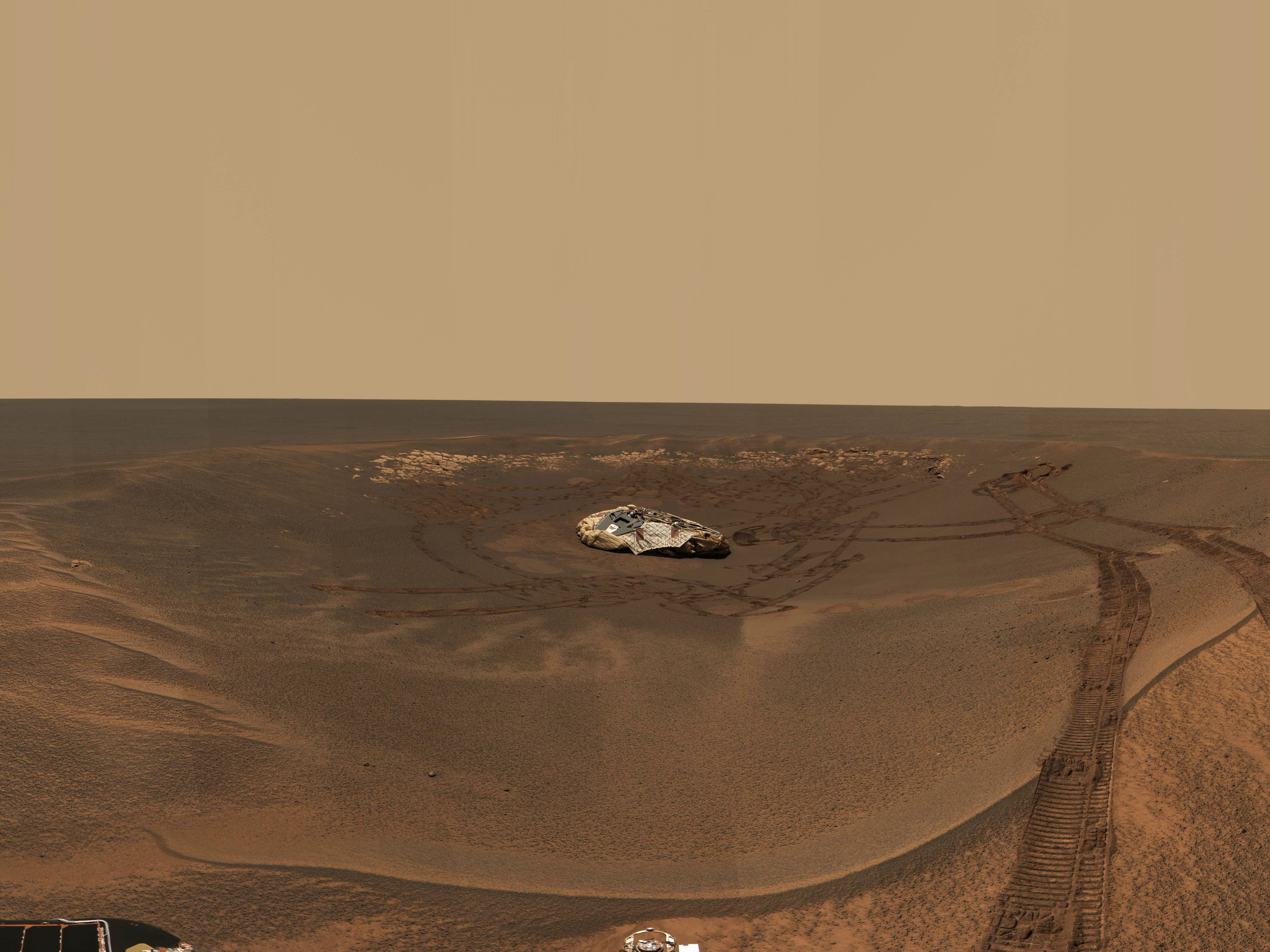
Opportunity Spies Its Backshell

From its new location at the inner edge of the small crater surrounding it, the Mars Exploration Rover Opportunity was able to look out to the plains where its backshell (left) and parachute (right) landed. Opportunity is currently investigating a rock outcropping with its suite of robotic geologic tools. This approximate true-color image was created by combining data from the panoramic camera's red, green and blue filters.

Image credit: NASA/JPL/Cornell
Browse Image (13 kB) | Large (373 kB)
An Old Friend
An Old Friend

This image shows two views of the backshell and parachute that helped deliver the Mars Exploration Rover Opportunity safely to the surface of Mars. The first, seen in the top left picture, is from the rover's perspective inside the small crater where it landed. The second, seen in the center, is from above and was taken by a camera onboard the Mars Global Surveyor orbiter. The white spot inside the crater in the upper right corner is the rover's lander, and the white mark in the lower left corner is the backshell.

Image credit: NASA/JPL/MSSS
Browse Image (36 kB) | Large (385 kB)
'You Are Here'
'You Are Here'

This map shows the Mars Exploration Rover Opportunity and its lander on the surface of Mars. The robotic geologist landed inside a small crater at Meridiani Planum on Jan. 24, 2004, PST. The image was taken by a camera onboard the Mars Global Surveyor orbiter.

Image credit: NASA/JPL/MSSS
Browse Image (22 kB) | Large (281 kB)
'You are here' (with models)

These maps show the Mars Exploration Rover Opportunity and its lander on the surface of Mars. The robotic geologist landed inside a small crater at Meridiani Planum on Jan. 24, 2004, PST. In the right image, computer-generated models of the rover and lander have been superimposed over the image of the actual rover and lander.

Image credit: NASA/JPL/MSSS/ASU
Browse Image | Medium Image (59 kB) | Large (1.9 MB)
'You Are Here' (no labels)

This map shows the Mars Exploration Rover Opportunity and its lander on the surface of Mars. The robotic geologist landed inside a small crater at Meridiani Planum on Jan. 24, 2004, PST. The white spot is the lander, and the small black spot northeast of it is believed to be the rover. The image was taken by a camera onboard the Mars Global Surveyor orbiter.

Image credit: NASA/JPL/MSSS
Browse Image (20 kB) | Large (272 kB)
Stone Mountain in Context

The colored square in this grayscale image taken by the panoramic camera onboard the Mars Exploration Rover Opportunity highlights the location of Stone Mountain, located within the rock outcrop at Meridiani Planum, Mars. Scientists are examining Stone Mountain with the instruments on the rover's instrument deployment device, or "arm," in search of clues about the composition of the rock outcrop.

Image credit: NASA/JPL/Cornell
Browse Image | Medium Image (63 kB) | Large (1.9 MB)
Stone Mountain
Stone Mountain

This color image taken by the panoramic camera onboard the Mars Exploration Rover Opportunity shows the part of the rock outcrop dubbed Stone Mountain at Meridiani Planum, Mars. Scientists are examining Stone Mountain with the instruments on the rover's instrument deployment device, or "arm," in search of clues about the composition of the rock outcrop.

Image credit: NASA/JPL/Cornell
Browse Image (62 kB) | Large (783 kB)
Speckled with Spherules

This false-color image taken by the panoramic camera onboard the Mars Exploration Rover Opportunity highlights the spherules that speckle the rock dubbed Stone Mountain. The colors in this picture were exaggerated or stretched to enhance the real difference in color between Stone Mountain and its collection of granular dots.

Image credit: NASA/JPL/Cornell
Browse Image (121 kB) | Large (1.8 MB)
A Patch of Stone
A Patch of Stone

The colorless square in this color image of the martian rock formation called Stone Mountain is one portion of the rock being analyzed with tools on the Mars Exploration Rover Opportunity's instrument deployment device, or "arm." The square area is approximately 3 centimeters (1.2 inches) across. Stone Mountain is located within the rock outcrop on Meridiani Planum, Mars. The image was taken by the rover's panoramic camera.

Image credit: NASA/JPL/Cornell/USGS
Browse Image (62 kB) | Large (384 kB)
Mars Rock Formation Poses Mystery

This sharp, close-up image taken by the microscopic imager on the Mars Exploration Rover Opportunity's instrument deployment device, or "arm," shows a rock target dubbed "Robert E," located on the rock outcrop at Meridiani Planum, Mars. Scientists are studying this area for clues about the rock outcrop's composition. This image measures 3 centimeters (1.2 inches) across and was taken on the 15th day of Opportunity's journey (Feb. 8, 2004).

Image credit: NASA/JPL/Cornell/US Geological Survey
Browse Image (60 kB) | Large (605 kB)
Mars Rock Formation Poses Mystery-2

This sharp, close-up image taken by the microscopic imager on the Mars Exploration Rover Opportunity's instrument deployment device, or "arm," shows a rock target dubbed "Robert E," located on the rock outcrop at Meridiani Planum, Mars. Scientists are studying the spherule, or small sphere, in the center of the image that appears to be protruding from the rock formation. This image measures 3 centimeters (1.2 inches) across and was taken on the 15th day of Opportunity's journey (Feb. 8, 2004).

Image credit: NASA/JPL/Cornell/US Geological Survey
Browse Image (39 kB) | Large (468 kB)
Reconstructing the Scene of Landing

This map of the Mars Exploration Rover Opportunity's new neighborhood at Meridiani Planum, Mars shows remnants of the rover's landing, including its lander; backshell and parachute; first bounce mark; and the site where its heat shield impacted the surface. The image was taken by a camera onboard the Mars Global Surveyor orbiter.

Image credit: NASA/JPL/MSSS
Browse Image | Medium Image (195 kB) | Large (786 kB)
Reconstructing the Scene of Landing (no labels)

This map of the Mars Exploration Rover Opportunity's new neighborhood at Meridiani Planum, Mars shows remnants of the rover's landing, including its lander; backshell and parachute; first bounce mark; and the site where its heat shield hit the surface (see labeled version of image for exact locations). The image was taken by a camera onboard the Mars Global Surveyor orbiter.

Image credit: NASA/JPL/MSSS
Browse Image | Medium Image (189 kB) | Large (768 kB)
'X' Marks the Spot
"X" Marks the Spot

This map of the Mars Exploration Rover Opportunity's new neighborhood at Meridiani Planum, Mars, shows the surface features used to locate the rover. By imaging these "bumps" on the horizon from the perspective of the rover, mission members were able to pin down the rover's precise location. The image consists of data from the Mars Global Surveyor orbiter, the Mars Odyssey orbiter and the descent image motion estimation system located on the bottom of the rover.

Image credit: NASA/JPL/MSSS/ASU
Browse Image | Medium Image (259 kB) | Large (8.5 MB)
Opportunity's Hole in One

This computer-generated visualization depicts an overhead view of the path Opportunity took when it landed at Meridiani Planum, Mars. A red line shows the path of the spacecraft's descent and bouncing along the surface. The line is superimposed on a mosaic of the three images taken during descent by the descent image motion estimation system camera, located on the bottom of the lander. Initially, the Opportunity lander was traveling east, but near the end of its descent, it began moving north. When the lander was released from the parachute, the spacecraft bounced to the north into the crater shown at the top of the image. North is indicated by the red-tipped white arrow in the coordinate axes and east, by the green-tipped white arrow.

Image credit: NASA/JPL
Browse Image (19 kB) | Large (365 kB)
Opportunity's Hole in One (Side View)

In this side view of the path the Mars Exploration Rover Opportunity took when it landed at Meridiani Planum, Mars, a computer-generated red line shows the path of the spacecraft's descent and bouncing along the surface. The line is superimposed on a mosaic of the three images taken during descent by the descent image motion estimation system camera, located on the bottom of the lander. Initially, the Opportunity lander was traveling east, but near the end of its descent, it began moving north. When the lander was released from the parachute, the spacecraft bounced to the north into the crater shown at the top of the image. North is indicated by the red-tipped white arrow in the coordinate axes and east, by the green-tipped white arrow.

Image credit: NASA/JPL
Browse Image (18 kB) | Large (253 kB)
Opportunity Bounces to a Stop

In this close-up view of the path Opportunity took when it landed at Meridiani Planum, Mars, a computer-generated red line shows the spacecraft's bounce motions as it landed at Meridiani Planum, Mars. The spacecraft bounced north approximately 26 times while safely encased in airbags, until it came to a stop inside the crater to the right of the image. The red line is superimposed on a mosaic of the three images taken during descent by the descent image motion estimation system camera, located on the bottom of the lander.

Image credit: NASA/JPL
Browse Image (8 kB) | Large (163 kB)
Found You!

This map of the Mars Exploration Rover Opportunity's new neighborhood at Meridiani Planum, Mars, demonstrates how engineers honed in on the location of the rover. The larger blue ellipse shows the projected landing area just before arriving at Mars. The black ellipse denotes the first approximation of the rover's location after landing based on radio signals received by NASA's Deep Space Network during entry, descent and landing. The white cross points to the rover's precise location based on radio signals sent from the surface both directly to Earth through the Deep Space Network and through NASA's Mars Odyssey orbiter.

Image credit: NASA/JPL/MSSS/ASU
Browse Image (47 kB) | Large (374 kB)

JPL Image Use Policy

USA.gov
PRIVACY   I   IMAGE POLICY   I   FAQ   I   SITEMAP   I   CREDITS