NASA Jet Propulsion Laboratory California Institute of Technology JPL HOME EARTH SOLAR SYSTEM STARS & GALAXIES SCIENCE & TECHNOLOGY JPL Email News RSS Mobile Video
Follow this link to skip to the main content
JPL banner - links to JPL and CalTech
left nav graphic Overview Science Technology The Mission People Spotlights Events Multimedia All Mars
Mars for Kids
Mars for Students
Mars for Educators
Mars for Press
+ Mars Home
+ Rovers Home
Features
List of All Features
Opportunity Celebrates One Mars Year!

December 12, 2005

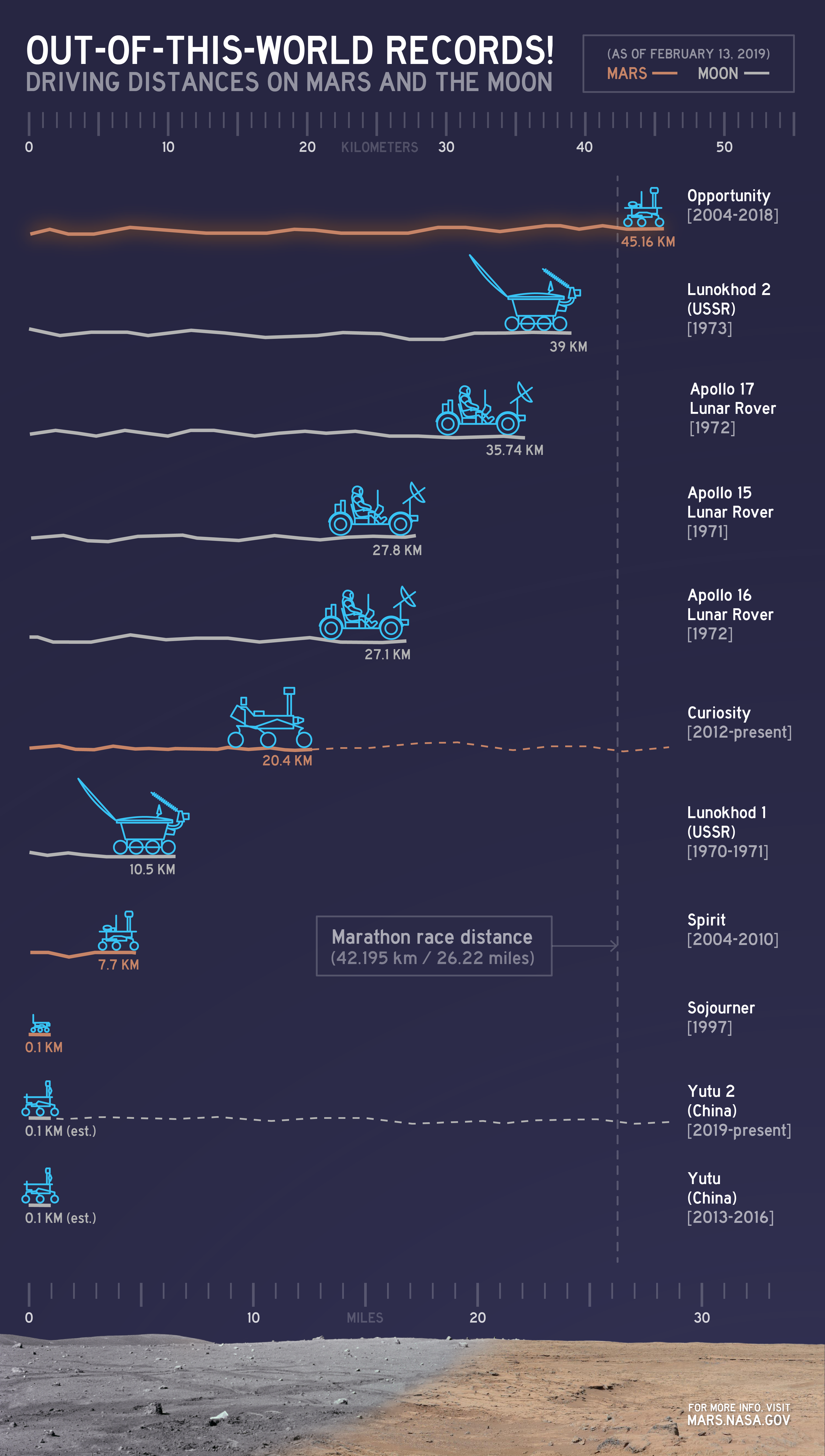
Seemingly touched with a load of luck from the giddy-up, Opportunity has been galloping since she strutted off of her lander, some 670 sols ago. A mission planned for 90 days has turned into an adventure that's lasted nearly two Earth years! With over four miles on her odometer, Opportunity has returned over 58,000 images. The ground covered and the science transported back across the void of space has helped us see into our planetary neighbor's alluringly watery past.

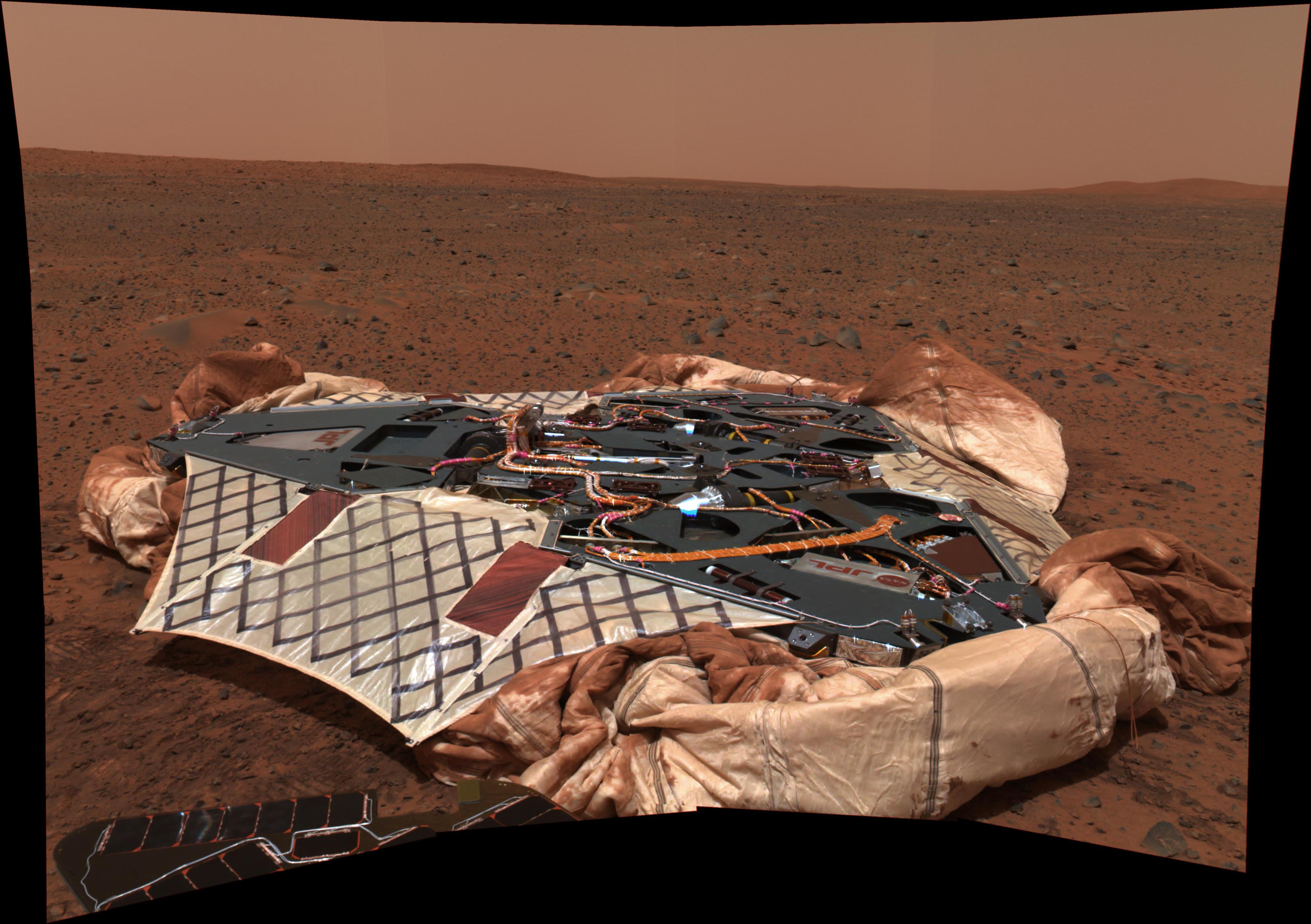
This black and white image was one of the first sent back by the Opportunity rover.  In the foreground are part of the rover's solar panels, covered with square solar cells.  The lander is also visible, splayed out to allow the rover to exit it.  Between the lander petals are the fabric 'batwings' that filled the gaps, providing additional exit routes.  The infamous outcrop where the first bedrock on Mars was seen up close is in the background.
This 360-degree panorama is one of the first images beamed back to Earth from the Mars Exploration Rover Opportunity shortly after it touched down at Meridiani Planum, Mars. The image was captured by the rover's navigation camera. Image Credit: NASA/JPL-Caltech
Larger Image

In this approximate-true color image, the rock dubbed 'Berry Bowl' is featured.  The rock looks, very roughly, like a triangle with the upper tip cut off.  This fruitful target is covered in the small BB-sized 'blueberries' that turned out to be hematite-rich spherules.  In this middle of the image is a hole, made by the rock abrasion tool to investigate the material beneath the weathered rind of the rock.
This image from the Mars Exploration Rover Opportunity's panoramic camera is an approximate true-color rendering of the exceptional rock called "Berry Bowl" in the "Eagle Crater" outcrop. Image Credit: NASA/JPL-Caltech/Cornell
Larger Image
"Alien" Surroundings Give Up Watery Clues

Like golfers on an extremely good day, rover navigators initially plopped Opportunity smack in the middle of a crater full of martian mystery and history – an interplanetary hole in one.

"We could have landed in a place and roved for two months before we saw anything different, but nearly every day with Opportunity, we've encountered amazing complexity in the terrain," said Joy Crisp, Mars Exploration Rover project scientist.

The main puzzle NASA intended the rovers to unravel was the story of water on the red planet. The first bedrock seen on Mars, bright and blatant in the very first pictures Opportunity sent home, marked the beginnings of an answer. Within just weeks of landing, excited scientists poured over pictures and data that clearly indicated the effects of water on layered rock, and the evidence just kept coming.


In this approximate-true color image, the phenomenon known as 'crossbedding' is featured.  This means that the rocks show clear effects of water's presence.  There is evident layering caused by flowing water.  In this image two distinct rocks are visible, embedded in sand.  Their texture is 'ripply' from water's effects.
This image taken by the Mars Exploration Rover Opportunity's panoramic camera shows the rock nicknamed "Last Chance," which lies within the outcrop near the rover's landing site at Meridiani Planum, Mars. The image provides evidence for a geologic feature known as ripple cross-stratification. NASA/JPL-Caltech/Cornell
Larger Image

Curious bead-like objects piqued scientists'interest at once. The beads, or "blueberries" as they came to be known, turned out to be rich int hematite, a mineral that often forms in water. Distinct layering in some rocks (called "crossbedding") showed that water once flowed there on the surface of Mars, leaving ripple-like curves in the outcrop rocks. More recently, a rock was found in which the chemistry indicated the presence of sodium chloride (table salt), which only forms when water has been present.

Like Goldilocks, searching for just the right bowl of hearty goodness, Opportunity tried craters of different sizes to find the most fruitful science results. Each of the major craters visited has been more satisfying than the last. As Opportunity explored progressively larger and deeper craters, more of the martian past was revealed, layer by layer. Her odyssey has shown that water was present not only once, but washed through and affected the area multiple times.

"Signs of water are everywhere! The area was soaked, over and over. First, there was the water from which sulfate salt precipitated. Then, for the rocks at the top of craters, there was water that flowed along, transported and broke down pieces of rock, then deposited it layer by layer. Then, there was water that came and soaked the ground in perhaps several episodes," Crisp enthused.

Some scientists wondered out loud, saying, "how good can this mission get?"


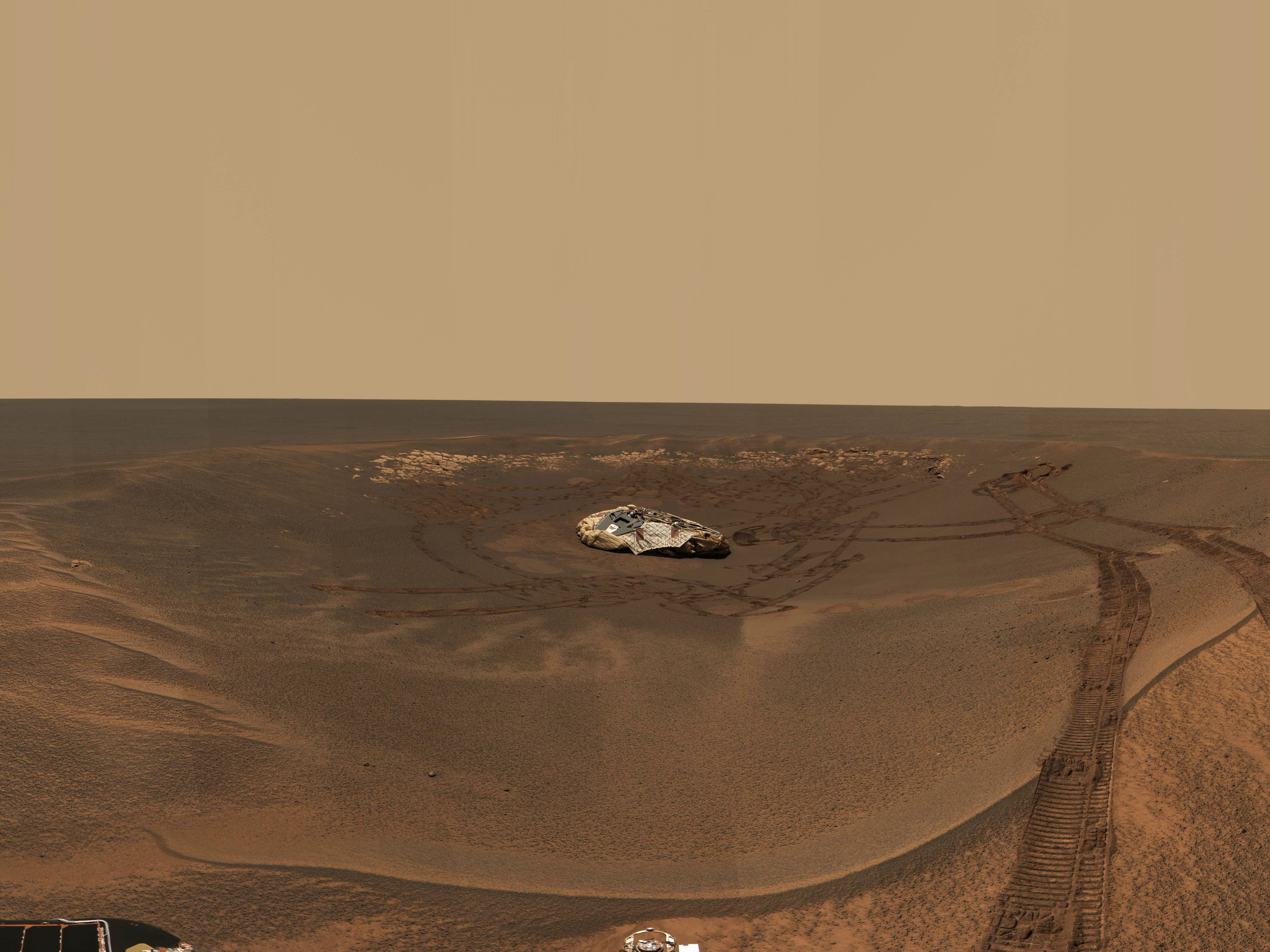
In this approximate-true color panoramic image, the large crater called 'Endurance' is featured.  The familiar orange-red martian color paints a stunning picture of this formidable depression.  Opportunity took this picture from the south rim.  The steep slopes of the crater are clearly visible as are the wind-blown sand ripples in the bottom, center of the crater.
This 360-degree panorama shows "Endurance Crater" and the surrounding plains of Meridiani Planum. This is the second large panoramic camera mosaic of Endurance, and was obtained from a high point near the crater's south rim. Image credit: NASA/JPL-Caltech/Cornell
Larger Image
Cruising the Crater Course

Apparently, it gets pretty good for this lucky rover. For much of Opportunity's four-mile trek, it's been like driving in a parking lot, noted rover driver Scott Maxwell. However, trickier maneuvers have been necessary on some taxing terrain. On the way out of her first crater, Opportunity experienced slippage in the loose soil. Engineers were challenged to find a safer way out, and worked hard to find a successful exit route. That knowledge would come in handy later, when Opportunity reached the stadium-sized "Endurance Crater."

The big question then loomed: risk Opportunity's demise by sending her into a crater she might not be able to exit? After grueling tests that pushed the design limits of rover surrogates on slopes back on Earth, engineers gave Opportunity the go-ahead to brave the downhill journey. After spending many months studying the crater's deep, complex rock layers, Opportunity climbed out intrepidly, and went on to investigate her own crashed heat shield (discarded shortly after entry through the martian atmosphere), discover a meteorite that once made its own fiery journey through the sky, and maneuver through bizarre "etched terrain."


Beauty Can Be Beastly

Traveling to etched terrain turned out to be an aesthetic bonus, but a bit of a mobility challenge. Ripples in the terrain, presumably formed by wind, look like still soil waves. As pleasing as they are to the eye, they can pose a danger to Opportunity. An unexpected hiatus came when the rover got stuck in a ripple called "Purgatory." Talented rover drivers eventually eased Opportunity out, and put their lessons learned to good use.

"Now we have the rover stop about every five meters (16 feet) to conduct a ‘slip check," Maxwell said. "It slows us down, but it's safer. We encountered a test case with the ripple ‘Telluride,' and were relieved Opportunity did what she was supposed to do!"

This image is a brilliantly-colored mosaic of Opportunity 'stuck' in the sand dune 'Purgatory' The image is from the vantage point of the rover, looking down at itself.  Bright hues of green, blue, magenta and red indicate the respective heights of the surrounding soil ripples.
This mosaic of navigation-camera frames from NASA's Mars Exploration Rover Opportunity, presented in a vertical projection, shows the rover's position after it dug itself to wheel-hub depth in a small dune during its 446th martian day, or sol (April 26, 2005). The colors are coding for information about relative elevations in the surrounding area. Red areas are the highest in the image, green areas the lowest. The difference between red and green is about 70 centimeters (28 inches). Image credit: NASA/JPL-Caltech
Larger Image
This black and white image is made mostly from orbital data, but also from the descent camera on the rover itself.  It highlights the entire journey Opportunity has made so far.  At the top a red line traces the rover's path from its landing-site crater ('Eagle'), to 'Endurance Crater' and then 'Erebus Crater' and all points between.  At the very bottom of the image is the enormous 'Victoria Crater,' where science and engineering team members hope the rover will make it to.
This image shows the route that NASA's Mars Exploration Rover Opportunity had driven through its 659th Martian day, or sol, (Dec. 1, 2005) relative to the potential destination of "Victoria Crater" farther south. Image Credit: NASA/JPL-Caltech/MSSS/OSU


Larger Image

Bonus Time

Although both rovers are aging, rover handlers are diagnostic geniuses who have tackled daunting software and hardware problems from millions of miles away. Having lasted seven times longer than expected, parts are slowly wearing out, and unknown challenges certainly lie ahead. Still, the team is prepared to guide their robotic explorers for as long as they are able to roam. Fingers are crossed that Opportunity will reach the distant, enormous depression nicknamed "Victoria Crater," 800 meters (a half mile) in diameter.

"Victoria is a potential ‘time tunnel,' allowing access to ancient martian material that otherwise would be buried deep beneath the surface and inaccessible," said John Callas, deputy project manager and science manager. "The great adventure continues, and both rovers look forward to starting a second martian year of discovery."

USA.gov
PRIVACY    |     FAQ    |     SITEMAP    |     CREDITS